3WE
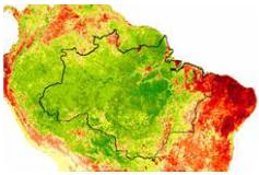
 Amazonas
 Meshlium
 Satelite
 Zigbee Kit
Project 3WE With registration number TSI-020100-2009-166 has been co-funded by the Spanish Ministry of Industry, Tourism and Commerce in the framework of the National Scientific Research, Developement and technological Information through 2008-2011
The key goal of the project is to develop a web based technology platform which enables a real time monitoring of environmental factors (temperature, humidity, CO2 levels...etc) which take place in carbon exchanges between the atmosphere and forest soils, and provide a method of evaluating changes in carbon absorption processes.
Given the importance of the mechanisms defined in the Kyoto Protocol in order to reduce greenhouse gas emissions, an improved understanding of forests role as carbon sinks and CO2 fluxes is strongly desired. The key goal of the 3WE project is to develop a web based technology platform which enables a real time monitoring of environmental factors such as temperature, humidity or CO2 levels which take place in carbon exchanges between the atmosphere and forest soils. These data are obtained both from remote sensing using satellite images and through wireless sensor networks connected to the Internet. Data captured by the sensor network is real-time transmitted, stored in a database and correlated with the information obtained by remote sensing in order to measure CO2 absorption processes.
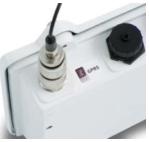
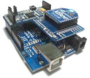
CeDInt-UPM has participated in the deployment of a wireless sensor network using ZigBee technology in order to measure temperature, humidity and light levels as well as dasometric parameters of a forest located in the north of Spain. CeDInt-UPM has also developed a web platform which allows real-time monitoring of data gathered by the sensor network.
Project General Objectives:
3WE project aims to validate avoided deforestation of forest soils as a Clean Development Mechanism (CDM). This mechanism is based upon gathering data through a wireless sensor network and satellite remote sensing.
CeDInt objectives within the project:
CeDInt-UPM has taken part in the development of a wireless sensor network and a web-based application for remote sensing monitoring.
Technologies:
The main technologies used in the project are semiconductor-based sensors to measure humidity, light and temperature, satellite remote sensing, ZigBee-based wireless networks and web technologies. Specific technologies used by CeDInt are ZigBee and IEEE 802.15.4, MySQL, MapServer, Javascript, PHP and Drupal.
Applications:
he main goal of the project is to develop a Clean Development Mechanism (CDM) in order to validate forest soils as carbon sinks. CeDInt-UPM has implemented a web-based application for real-time monitoring of remote sensing and data acquired by a wireless sensor network. With the purpose of visualizing the remote sensing images remotely using a web browser, a Web Map Service (WMS) has been deployed. The web application also shows graphical information about the data obtained by the sensors, allowing comparison between different parameters throughout a period of time.
