Ecommontech
 Application
 Detail of sensor instaled in pilot area of Urbión Forest
 Control Center
 Project Web Page
Project co-funded by the Spanish Ministry of Industry, Energy and Tourism(ref. IST-020100-2010-289) within the National Plan for Scientific Research, Technological Development and Innovation Avanza2 between 2008 and 2012.
The aim of the project Ecommontech is to develop a tool suitable to certify that a particular area is being reforested through a REDD mechanism (Reducing Emissions from Deforestation and forest Degradation). The indicators for this calculation will be obtained through a network of autonomous devices composed of sensors and connected by ZigBee and images obtained by satellite remote sensing.
Sumary of CeDInt contribution to the project
CeDInt-UPM has participated in the deployment of a wireless sensor network using ZigBee technology in order to measure temperature, humidity and light levels as well as dasometric parameters of a forest located in the north of Spain. CeDInt-UPM has also developed a web platform which allows real-time monitoring of data gathered by the sensor network.
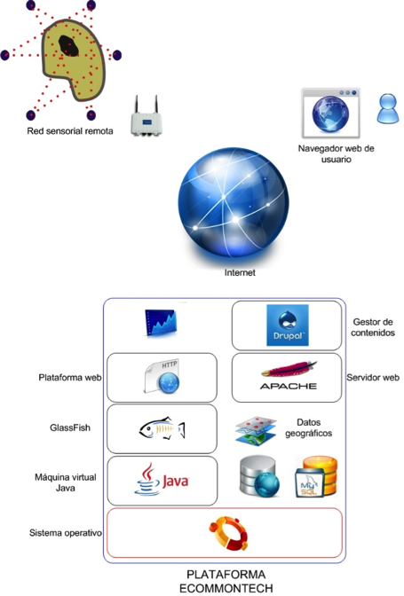
Platform Scheeme
General Project Objectives:
Ecommontech project aims to validate avoided deforestation of forest soils as a Clean Development Mechanism (CDM). This mechanism is based upon data collection through a wireless sensor network and satellite remote sensing.
CeDInt Activity within the Project Objectives:
CeDInt-UPM has taken part in the development of a wireless sensor network and a web-based application for remote sensing monitoring. This application also allows the visualization of remote sensing images in order to compare variations in forest surfaces.
Technologies:
The main technologies used in the project are semiconductor-based sensors to measure humidity, light and temperature, satellite remote sensing, ZigBee-based wireless networks and web technologies.
Technologies used by CeDInt for the project:
Specific technologies are ZigBee and IEEE 802.15.4, MySQL, MapServer, Javascript, PHP and Drupal.
Applications:
The main goal of the project is to develop a Clean Development Mechanism (CDM) based on Reducing Emissions from Deforestation and forest Degradation (REDD).
Aplications developed by CeDInt for the project:
CeDInt-UPM has implemented a web-based application for real-time monitoring of remote sensing and data acquired by a wireless sensor network. With the purpose of visualizing the remote sensing images remotely using a web browser, a Web Map Service (WMS) has been deployed. The web application also shows graphical information about the data obtained by the sensors, allowing comparison between different parameters throughout a period of time. The application also allows the visualization of remote sensing images in order to compare variations in forest surfaces.
