eGEO


Project funded by the Ministry of Economy and Competitivity (MinECo) within the INNPACTO 2012 framework with project number: IPT-2012-0552-380000
This project aims to develop a new service which will be able to modify remotely and automatically the lighting level, air conditioning and security conditions of any room within a Smart building. This set of actions belong to a scene which has been created attending the user’s preferences. In order to determine which scene is active in a certain moment of time the geographic location of the user is used.
Once the system finds out the location of the user, it determines the distance between himself and the user’s home and depending on this distance a different scene is activated. This scene can perform actions such as turning on/off the security system or the HVAC.
Everything described above has to be performed without sacrificing energy efficiency, ie, using the available resources of this smart building properly and efficiently.
The project aims to achieve the following goals
- Design and development of a local management platform for smart buildings which will be able to manage installed systems and to execute energy saving or security services.
- Design and development of a decision platform which according to the user’s location with respect to their home it will decide the actions to be performed.
- Development of a location system which aims to get the user’s location with an error of few meters.
CeDInt Objectives within the project
The participation of CeDInt in this Project follows three different areas: design and development of a local management platform for smart buildings, development of a decision platform and improvement of energy efficiency in buildings.
The following figure shows the schema of the developed solution.
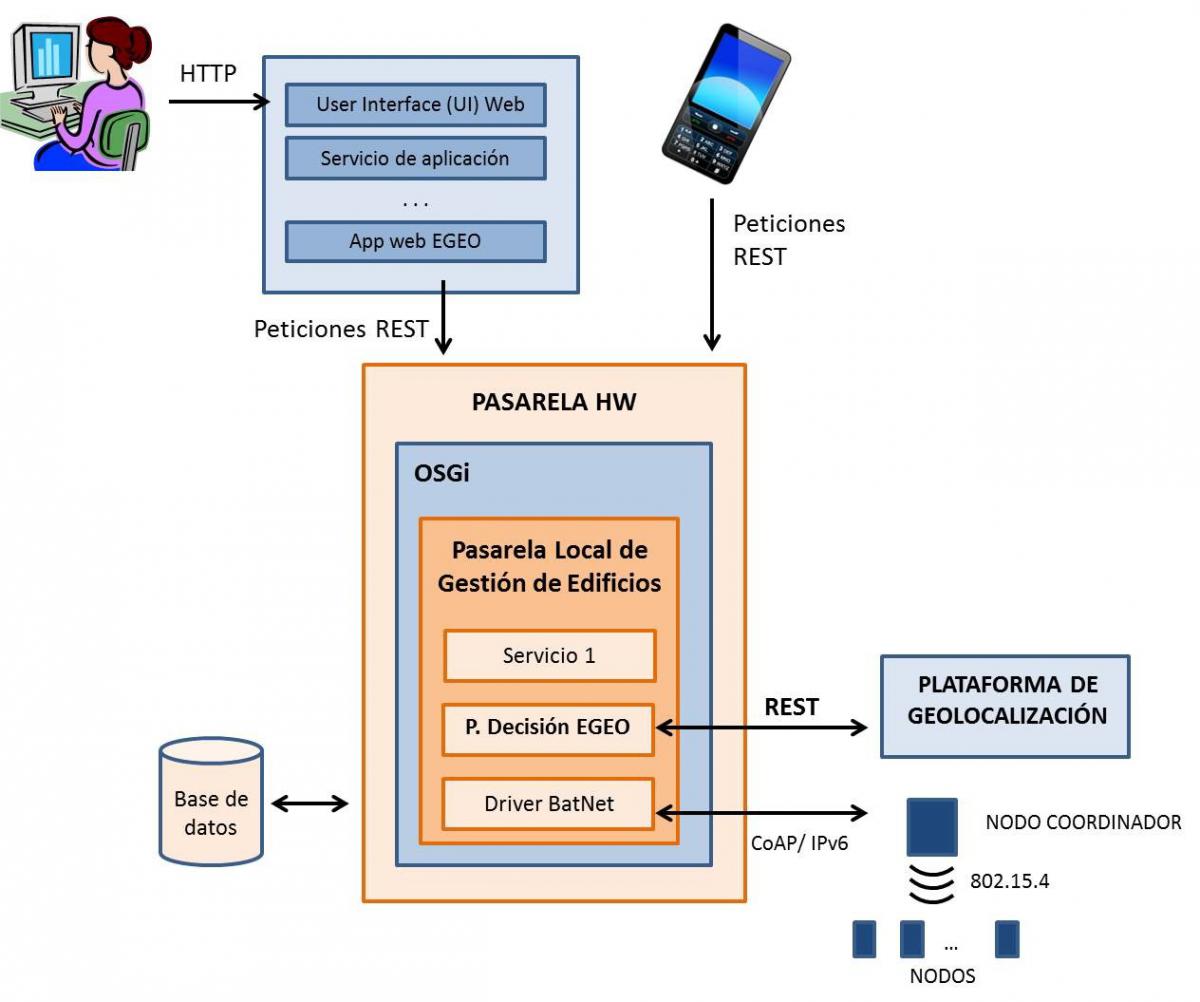
Figure1. Technologic solution set for Smart buildings management through geolocation.
The management platform makes possible the communication with several technologies related to domotic management, communication between applications and services and it creates a model which includes the elements that can be managed inside the user’s house.
The components’ integration inside the platform requires a modular architecture. Due to this fact, the OSGi specification is used. OSGi specification (Open Services Gateway Initiative) is a Java specification which provides a model of dynamic component where the different elements (called bundles) can be installed, activated (executed) or deactivated dynamically.
The communication system of this platform can be observed in figure 2.
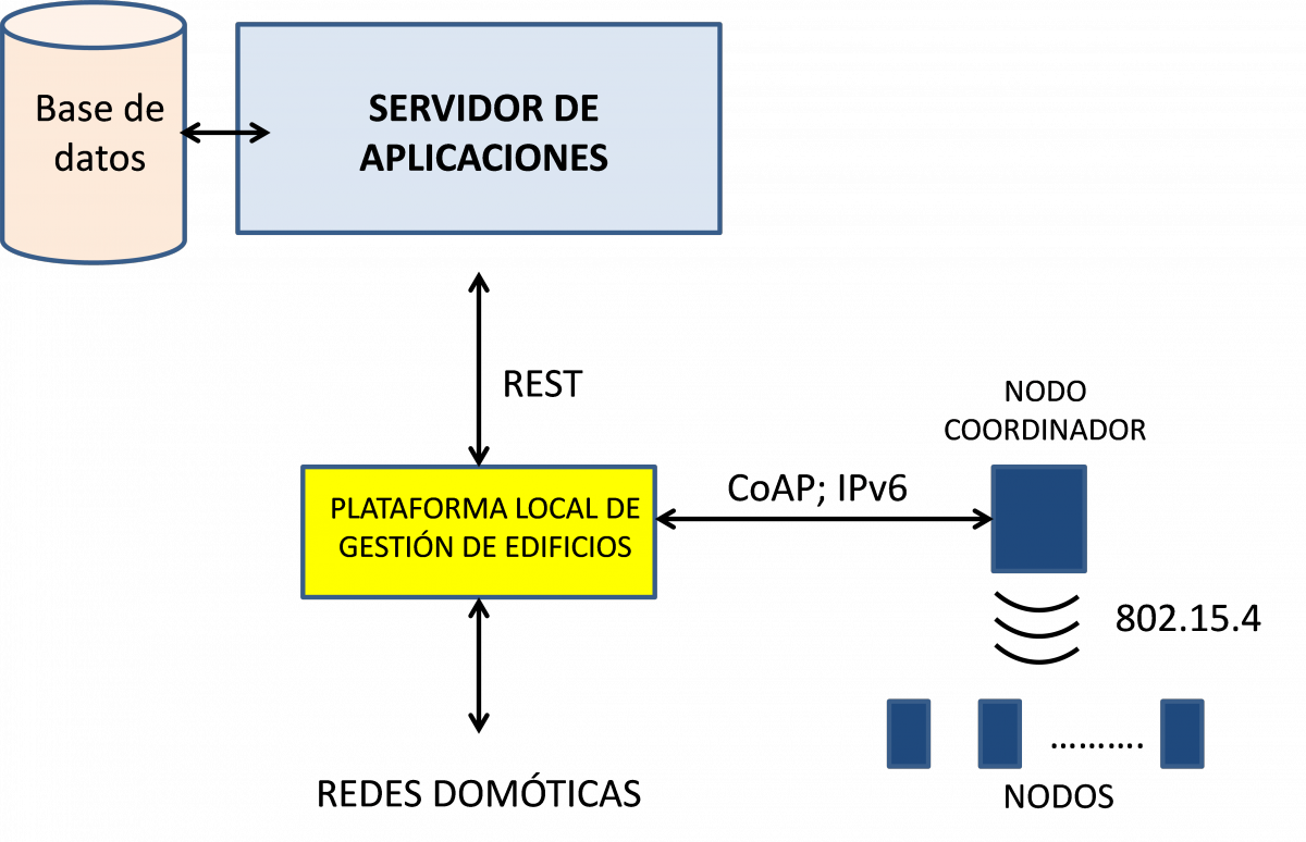
Figure 2. Local Management Platform Architecture
With the aim of creating an abstraction layer which will allow to manage devices from the decision platform, the architectural style REST (REpresentational State Transfer) was used to develop the external interface of the local management platform.
This technology was selected due to the standard way of implementing remotely executable services it provides. REST is also an intuitive and easy to use tool which provides developers with an easy and agile way of working.
The decision platform is a software module which executes a set of management actions in the building. To do it, this module uses input data provided by the location and the local management platforms. The control actions executed by the decision platform are also sent to the local management one so that and the possibility of reusing it were the reasons why this decision module was integrated in the local management one.
Finally, a geolocation platform has also been developed. Its aim is to meddle between the local management platform and the main location platform called MovilForum and owned by Telefónica España. This platform has been designed and implemented as an application that runs over the management one so its functionality can be easily accessible.
The following figure shows how the modules of this Project are integrated.
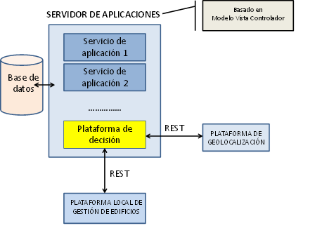
Figura 3. Arquitectura general del proyecto eGeo.
A web interface has also been developed so a user can find this system easy and intuitive to use. This interface allows the user to set the coordinates of his housing and to start and stop the location service. The communication between this interface and the geolocation platform through REST technology.
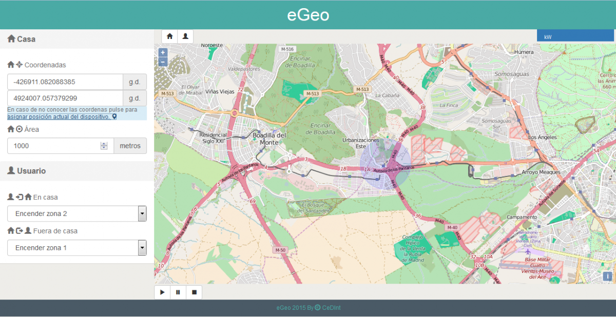
Figure 4. Web Interface of the location platform
The user can also notice the distance between himself and his housing in a graphical way.
Technologies:
Technologies used by CeDInt within the project
The main technologies used in this project are:
- Equinox (OSGi): Java jdk, Maven, JUnit, Selenium, Rest-Assured
- Ontologies: RDF, OWL, Jenna
- Home Automation Protocols: KNX (Calimero), COAP + IPSO
- IP Communication Protocols: Rest, JSON
- Graphical User Interfaces: HTML5, Javascript, JQuery, OpenLayers, Bootstrap
Development Tools: Eclipse, SVN, Hudson, Artifactory, Protegé (ontologies)
Applications:
The applications developed in this project will allow the user to access to the configuration of the monitoring and management platform, as well as the one of the decision platform.
Another application will be developed, where the user will be able to access its own location, as well as to start and cancel this service.
Applications developed by CeDInt in this project
The applications developed by CeDInt are the following ones:
- Monitoring and management application and rules engine.
- Geolocation app (eGeo).
